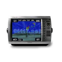
This mid-sized 4000 series chartplotter fills the gap between the smaller GPSMAP 4008 and the wider GPSMAP 4012. Like its counterparts, the 4010 serves as your all-in-one nerve center for the Garmin Marine Network. This chartplotter has crisp, video-quality resolution on a 10.4-inch diagonal SVGA display as well as a worldwide, satellite-enhanced basemap. By connecting to the Garmin Marine Network, you can add sonar, radar and video functionality. For even more enhanced features and detailed regional cartography, you can add the optional BlueChart? g2 Vision card.
The 4010 features a worldwide basemap with high-quality satellite images in place of more traditional maps. A high-speed processor draws maps quickly, while its simple, intuitive interface makes navigation easy. To keep tabs on your engine room or other areas of your boat, you can also connect a live video feed through its video input option.
With optional BlueChart g2 Vision SD cards, you can add a whole new dimension of exceptional features to your chartplotter.
MarinerEye view and FishEye view provide you a 3-dimensional perspective of map information, both above and below the waterline.
High-resolution satellite images and aerial photographs help you orient yourself in unfamiliar areas.
Auto Guidance technology searches through all relevant charts to automatically create a route from where you are to your destination, avoiding charted obstacles, shallow water, buoys and other obstructions. Just click on your destination and the 4010 does the rest.
Connect to the Garmin Marine Network
The 4010 connects easily to the high-speed Garmin Marine Network, so you can interface with additional multi-function displays and add remote sensors such as the new GFS 10 fuel sensor. Once connected, you can share information between the 4010 and other chartplotters on your boat. You can also add high-powered radar, sonar and video to your system. For easy operation, an optional wireless remote is also available.
硬件和性能: | |
| 尺寸,长x宽x高: | 13.4" x 8.9" x 4.2" (34 x 22.6 x 10.7 cm) |
| 显示屏尺寸,长x宽: | 8.3" x 6.3", 10.4" diagonal (21 x 16 cm, 26.4 cm diagonal) |
| 分辨率,长x宽: | 800 x 600 pixels |
| 显示类型: | SVGA display |
| 重量: | 7.8 lb (3.5 kg) |
| 电池: | none |
| 电池使用时间: | none |
| 防水: | 是(IPX7) |
| 高灵敏度接收机: | 有 |
| 天线: | external |
| NMEA输入/输出: | NMEA 0183, NMEA 2000 |
地图和内存: | |
| 电子底图: | 有 |
| Preloaded maps: | 无 |
| 可附加地图: | 有 |
| 内存: | none (cannot load maps to internal memory) |
| 支持存储卡: | SD? card slot (BlueChart g2 Vision cards sold separately) |
| 航点/收藏夹/位置: | 1,500 |
| 航线: | 20 |
| 航迹记录: | 10,000 points; 20 saved tracks |
特征: | |
| 兼容Garmin雷达: | 有 |
| 兼容Garmin声纳: | 有 |
| 兼容Garmin Marine Network?: | 有 |
| 触摸屏: | 无 |
| 支持AIS(跟踪目标船的位置): | 有 |
| 支持DSC(显示带有DSC的VHF无线电的位置数据): | 有 |
| 声音报警: | 有 |
| 潮汐表: | 有 |
| 打猎钓鱼日程: | 无 |
| 太阳月亮信息: | 有 |
| 三维地图视角: | 是(可选BlueChart g2 Vision海图卡) |
| 自动引导: | 是(可选BlueChart g2 Vision海图卡) |
| 兼容美国XM WX天气预报无线电: | 有 |
| 建议路线规划: | 无 |
| 语音播报(例如,前方500米右转): | 无 |
| 语音播报路名(例如,前方500米右转到霄云路) : | 无 |
| 耳麦/音频输出: | 无 |
| 音频/视频 输入/输出: | 有 |
| 可便携的: | 无 |
| 适用于汽车/摩托车: | 无 |
| 其它: | Interface Inputs/Outputs: 3 built-in network ports, 4 NMEA input (supports NMEA 2000), 2 NMEA output, 2 video inputs for onboard cameras, 1 SVGA PC monitor |