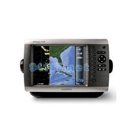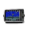
GPSMAP 2108 chartplotter has sunlight readable and high resolution quality on an 8” SVGA (800 x 600 pixels) display, easy to flush-mounts or bail-mounts in your boat. Features designed specifically for professional fishermen at more affordable cost to larger display chartplotters. The 2108 also sports a built-in, worldwide basemap and simple, straightforward buttons and menus. You can add the optional BlueChart? g2 SD card for more enhanced map features. Except with English user interface (UI), the 2108 is the first Garmin chartplotter equipped with Asian language pack, including Traditional Chinese, Simplified Chinese, Indonesian Bahasa, Thai, and Myanmar.
With just a few buttons and a simple, intuitive interface, the GPSMAP 2108 makes navigating virtually effortless. By connecting to the Garmin Marine Network, you can add sonar, radar, and second GSPMAP 2108 as separately individual station to expand the system. The GPSMAP 2108 has an SD? card slot so you can add additional detailed maps worldwide without connecting to a computer.
Where applicable, the GPSMAP 2108 can connect with a powerful sounder (GSD21 or GSD22) and dual frequency transducer that clearly paints depth contours, fish targets and structure whether you’re fishing in freshwater or off the coast. Capable of connecting to Garmin NMEA 0183 Intelliducer for various depth fathoming sensors.
The 2108 connects easily to the high-speed Garmin Marine Network, so you can add radar and sounder easily. Capable of interfacing with the additional 2108 charplotter, adding sounders and radars thru Garmin network hub (GMS10). All networked chartplotters can share information of the radar and sounder.
硬件和性能: | |
| 尺寸,长x宽x高: | 11.2" x 7.0" x 4.6" (28.5 x 17.8 x 11.7 cm) |
| 显示屏尺寸,长x宽: | 6.9" x 5.2", 8.4" diagonal (17.5 x 13.2 cm, 21.3 cm diagonal) |
| 分辨率,长x宽: | 800 x 600 pixel |
| 显示类型: | SVGA display |
| 重量: | 1.4 kg |
| 电池: | none |
| 电池使用时间: | none |
| 防水: | 是(IPX7) |
| 高灵敏度接收机: | 无 |
| 天线: | GA29 (included) |
| NMEA输入/输出: | NMEA 0183 |
地图和内存: | |
| 电子底图: | 有 |
| Preloaded maps: | 无 |
| 可附加地图: | 有 |
| 内存: | N/A |
| 支持存储卡: | yes (g2 SD) |
| 航点/收藏夹/位置: | 5,000 |
| 航线: | 50 |
| 航迹记录: | 35,000 points; 30 saved tracks |
特征: | |
| 兼容Garmin雷达: | 有 |
| 兼容Garmin声纳: | 有 |
| 兼容Garmin Marine Network?: | 有 |
| 触摸屏: | 无 |
| 支持AIS(跟踪目标船的位置): | 有 |
| 支持DSC(显示带有DSC的VHF无线电的位置数据): | 有 |
| 声音报警: | 有 |
| 潮汐表: | 有 |
| 打猎钓鱼日程: | 有 |
| 太阳月亮信息: | 有 |
| 三维地图视角: | 无 |
| 自动引导: | 无 |
| 兼容美国XM WX天气预报无线电: | 无 |
| 建议路线规划: | 无 |
| 语音播报(例如,前方500米右转): | 无 |
| 语音播报路名(例如,前方500米右转到霄云路) : | 无 |
| 耳麦/音频输出: | 无 |
| 音频/视频 输入/输出: | 无 |
| 可便携的: | 无 |
| 适用于汽车/摩托车: | 无 |